Alternative Landfill Cover Project Profiles
Capillary Barrier ET Cover at Monticello Mill Tailings (USDOE), Monticello, UT
Last Updated: January 13, 2006 |
||
| Site Information | ||
| Site Name, Location: | Monticello Mill Tailings (USDOE), Monticello, UT USA
(EPA Region 8) |
|
| Site Type: | Hazardous and radioactive waste landfill | |
| Superfund Site: | Yes | |
| Federal Facility: | Yes | |
Project Information |
||
| Project Name: | Capillary Barrier ET Cover at Monticello Mill Tailings (USDOE), Monticello, UT | |
| Project Scale: | Demonstration | |
| Demonstration Program: | Alternate Cover Assessment Program (ACAP) | |
| Project Status: | Installed | |
| Date Installed: | July 2000 | |
| Project Description/ Purpose: | The purpose of this project is to monitor a portion of a full-scale capillary barrier ET cover to determine whether the percolation rate is less than 0.12 in/yr. The purpose of the cover is to not only limit the inflow of water but also to limit the outflow of radon gas. This project is included in the ACAP. Information about a lysimeter study being conducted at this site can be found in the online profile titled "Demonstration Capillary Barrier ET Covers at Monticello Mill Tailings Superfund Site." | |
| Monitoring System: | The ET cover at this site was installed above a compacted clay layer and 1.5 mm HDPE geomembrane; however, the ET cover will be monitored above the geomembrane, which will act as a lysimeter for monitoring a 3-hectare section of the full-scale cover. Soil monitoring stations were placed in three locations within the monitoring area, and a runoff plot was constructed over a 10m by 20m area. Water content reflectometers to measure soil moisture. Heat dissipation units to measure soil matric potential and soil temperature. | |
Cover Information |
||
| Cover Type: | Capillary Barrier Evapotranspiration | |
| Cover Size: | 3 hectares | |
| Design of Cover: | From surface downward: 8 inches of soil/gravel admixture, 36 inches of fine-grained soil, 12 inches of soil/rock admixture (biointrusion layer), 12 inches of fine-grained soil, geotextile filter, and 14 inches of sand | |
| Types of Vegetation: | Western wheatgrass, gray rabbitbrush, and sagebrush | |
| Drainage Layer: | No | |
| Biointrusion Layer: | Yes | |
| Gas Collection Layer: | No | |
| Performance Data Available: | Yes | |
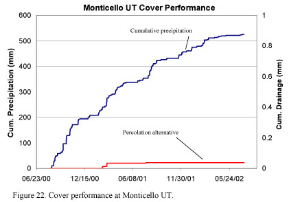
| Summary and Description of Performance Data: | The figure below shows the actual performance results for this cover during the period from August 2000 to July 2002. The percolation (infiltration) during the first year shown was less than 0.1 mm/yr, relative to precipitation of 350 mm/yr. The infiltration during the second year shown was negligible, relative to precipitation of 170 mm/yr. This figure was excerpted from the following source document, Alternative Cover Assessment Program, 2002 Annual Report, Desert Research Institute, available at http://www.acap.dri.edu/. | |
 |
||
| Comments: | Overall landfill size is 7.4 acres. | |
| Reference(s) | Bolen, M.M. and others. 2001. Alternative Cover Assessment Program: Phase II Report. University of Wisconsin-Madison. Geo Engineering Report 01-10. Madison, WI. September. Benson, C., and others. 2002. "Evaluation of Final Cover Performance: Field Data from the Alternative Cover Assessment Program (ACAP)." Proceedings, WM 2002 Conference, Tucson, AZ. February 24-28, 2002. Personal communication between Danielle Gratton, Tetra Tech EM Inc., and Bill Albright, Desert Research Institute. February 14, 2002. |
|
Point(s) of Contact |
||
| Primary Contact | ||
| Organization: | USDOE | |
| Name: |
Jody Waugh | |
| Address: | 2597 B 3/4 Road, Grand Junction, CO 81503 | |
| Phone: | 907-248-6431 | |
| Email: | jody.waugh@gjo.doe.gov | |
| RETURN TO LIST | ||